
GeoRank
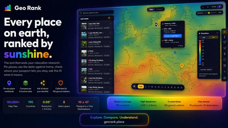
GeoRank compares places across 9 data layers so you can pin locations, see deltas from home, check visa access, and ask AI about your shortlist.
VisitPublished on:
July 13, 2026
Pricing:
About GeoRank
GeoRank is a free, no-signup interactive map that consolidates the scattered research process of relocating or spending an extended stay abroad into a single, powerful decision tool. Instead of juggling a dozen open tabs for weather, cost-of-living, visa rules, and nomad forums, GeoRank layers eight critical data sets over a global grid with approximately five-kilometer resolution. This includes sunshine and temperature data calibrated against 182 ground stations using SARAH-3, ERA5, and CHELSA sources, tax rates from OECD, PwC, and KPMG, per-passport visa and residency routes across 47 destinations and 10 passports, cost-of-living data from 478 cities, geopolitical risk assessments, and community-sourced Nomad Pulse sentiment. Users can pin candidate places, switch to Compare mode to see every metric as a delta against their current home, and ask an AI assistant that reasons only over their own shortlist. Built for the actual decision of where to live next, GeoRank transforms browsing data into actionable, comparative insights that end the relocation research cycle quickly and efficiently.
Features of GeoRank
Explore Globally with 9 Live Layers
Toggle any of nine live data layers directly on the map, including sunshine, temperature, rainfall, outdoor hours, taxes, visas and residency, cost of living, geopolitical risk, and Nomad Pulse sentiment. Pan across the globe and zoom down to approximately five-kilometer cells to see hyper-local data. Each layer is a live source you can stack, giving you a comprehensive, multi-dimensional view of any location on earth without switching between tools or websites.
Pin and Compare Against Your Home
Click any location to pin it to your shortlist, with support for up to 20 places saved across sessions. Switch to Compare mode and set your current home as a baseline. Every metric for every pinned location is then displayed as a delta: how much warmer, cheaper, safer, or differently taxed it is compared to where you live now. This relative view transforms absolute numbers into personally meaningful comparisons that accelerate decision-making.
AI Chat for Your Shortlist
The built-in AI assistant operates exclusively on your pinned locations, not a generic knowledge base. Ask questions like "Which of my 5 places has the best winter?" or "Score my shortlist by sunshine, cost, and low tax combined." The AI reasons across all your specific data points in one response, providing cited, grounded answers that compare tradeoffs between locations. This eliminates manual cross-referencing and delivers precise, actionable insights instantly.
Calibrated Data with Ground Truth
GeoRank does not rely on raw satellite data alone. It merges SARAH-3 satellite observations with ERA5 reanalysis data, then bias-corrects everything against 182 ground stations with orographic terrain corrections. This calibration covers locations from Reykjavik to Phoenix to Sydney, ensuring accuracy where raw data typically fails, such as in cloudy regions or high-altitude areas. The result is reliable, ground-truthed information you can trust for critical relocation decisions.
Use Cases of GeoRank
Digital Nomad Relocation Planning
A digital nomad with a UK passport is deciding between Tbilisi and Paphos for a six-month stay. They need at least 2,800 sunshine hours per year and low tax on foreign-sourced income. Using GeoRank, they pin both cities, set their home as baseline, and ask the AI. The tool instantly shows Paphos meets the sunshine threshold while Tbilisi falls short, but Tbilisi is considerably cheaper. The AI provides a clear tradeoff analysis with cited sources, enabling a fast, informed decision.
Family Relocation Assessment
A family with children is considering moving from London to either Lisbon or Valencia. They need to understand the full picture: climate, safety, cost of living, and visa requirements for their passports. By pinning both cities and comparing them against their current home, they see deltas for every metric. They can ask the AI "What are the tradeoffs between Lisbon and Valencia for a family?" and receive a comprehensive response that factors in all nine data layers, including geopolitical risk and community sentiment.
Remote Worker Tax Optimization
A freelancer with a US passport wants to minimize income tax while maintaining good weather and low cost of living. They explore the map, pin several candidate locations across Southeast Asia and Europe, and use Compare mode to rank them by tax delta against their current US state. The AI helps them understand which locations offer the best combination of low tax, sunshine, and affordability, with data sourced directly from OECD, PwC, and KPMG tax databases.
Seasonal Relocation Decision
A retiree wants to spend winters in a warm, sunny location with good healthcare infrastructure and low geopolitical risk. They use GeoRank to pin five potential winter bases across the Mediterranean and Central America. By asking the AI "Which of my pinned places is best for a winter base?", they receive a ranked analysis based on sunshine hours, temperature, safety scores, and visa duration for their passport. The delta view shows exactly how much warmer and sunnier each option is compared to their current home.
Frequently Asked Questions
Is GeoRank really free and does it require signup?
Yes, GeoRank is completely free to use and requires no signup or account creation. You can access all nine data layers, pin up to 20 locations, use Compare mode, and chat with the AI assistant without any registration. Your pinned locations are saved across sessions automatically, so you can return to your research at any time without losing progress.
How accurate is the data on GeoRank?
GeoRank uses a multi-source calibration approach to maximize accuracy. Sunshine and temperature data come from SARAH-3 satellite observations merged with ERA5 reanalysis, bias-corrected against 182 ground stations worldwide. Accuracy is plus or minus 8 percent for most locations, though high-altitude areas may see plus or minus 15 percent and coastal microclimates plus or minus 20 percent. Tax data is sourced from OECD, PwC, and KPMG, while cost-of-living data covers 478 cities globally.
How does the AI assistant work with my shortlist?
The AI assistant is designed to reason exclusively over your pinned locations and their specific data. It does not use a generic knowledge base or internet search. When you ask a question like "Which of my 5 places has the best winter?", it analyzes the sunshine, temperature, and other relevant metrics for each of your pinned locations and provides a comparative answer with cited sources. This ensures responses are grounded in your actual data and directly applicable to your decision.
What is Nomad Pulse and how is it collected?
Nomad Pulse is a community-sourced sentiment layer that tracks weekly enthusiasm from the digital nomad community. It processes social posts and online discussions to generate rising, stable, or falling signals per country and city. This layer helps you see where excitement and interest are building before it becomes mainstream, giving you an edge in identifying emerging hotspots or declining destinations based on real community feedback.
Similar to GeoRank

AI academic assistant for writing, research, presentations, and coding

Signage and kiosk infrastructure for AI agents. Your agent publishes images, video, streams, web pages and apps to screens via one plugin.screenRIG is

Privacy-first cookieless analytics that connects website traffic directly to real revenue.

Spin to decide: names, numbers, colors, or yes/no. Free wheel picker tools for teachers, streamers, and teams — no signup needed.

Online tally counter for tracking attendance, workouts, inventory, visitors, sports scores, habits, and everyday counting tasks.


