
Open User Map
Open User Map lets you build an interactive, user-driven WordPress map with frontend submissions and full customization, no coding or API key.
Visit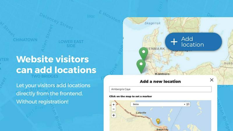
About Open User Map
Open User Map is a powerful, interactive maps plugin for WordPress that transforms how you collect and display location data. It enables website visitors to add, edit, and engage with locations directly on your map through frontend submissions, approval workflows, and extensive customization options. Built for non-developers and professionals alike, Open User Map requires zero coding, no Google Maps API key, and no complex setup. Simply install the plugin and launch an interactive, community-driven map in minutes. This tool is ideal for businesses, organizations, and individuals who want to crowdsource location information from their audience. Whether you run a tourism site, a local business directory, a real estate platform, or a community project, Open User Map gives you complete control over what gets published. Every user-submitted location goes through an approval workflow, ensuring only accurate and appropriate content appears. With over 15,000 active installs and 100% five-star ratings, it ranks as the number two map plugin on WordPress.org. The plugin offers advanced features like custom fields, categories with unique icons, lines and areas for routes and zones, upvoting and star ratings, and even the ability to turn any image into an interactive map. Open User Map balances simplicity with powerful functionality, making it the go-to solution for creating maps your visitors can contribute to.
Features of Open User Map
Frontend Location Submissions and Editing
Enable your website visitors to add and edit locations directly on your map without needing backend access. Users click "Add location," place a marker, and submit details like name, description, and custom fields. Every submission enters an approval queue, so you review and publish only the best content. Additionally, users can edit their existing locations, keeping your map current and accurate without manual updates from your side. This feature reduces your workload while empowering your community to contribute.
Marker Categories with Custom Icons and Filtering
Organize your map visually and functionally by grouping locations into categories, each with its own unique icon. This makes your map instantly scannable and professional. Visitors can filter markers by category, allowing them to quickly find specific types of locations like restaurants, parks, or events. Each location can belong to multiple categories, ensuring comprehensive representation. This feature is essential for maps with diverse data, improving user experience and navigation.
Lines and Areas for Routes and Zones
Go beyond simple point markers by adding lines, paths, zones, and regions to your map. Use this feature to highlight trails, service areas, event grounds, neighborhoods, or construction zones. Distances and area sizes calculate automatically, so routes and polygons include helpful measurements out of the box. This is perfect for hiking maps, delivery zones, campus guides, or any scenario where boundaries and paths add critical context for your visitors.
Custom Image as Map
Upload any image and transform it into a fully interactive map. This works for overlays, floor plans, event layouts, game maps, product diagrams, campus guides, or seating charts. Users can place markers directly on the image with the same powerful functionality as a traditional map. Add locations, display custom fields, enable filtering, and create an engaging, clickable experience tailored exactly to your use case. This feature expands what a map can be beyond geographic boundaries.
Use Cases of Open User Map
Local Business Directory and Review Map
Build a community-driven directory where visitors add and rate local businesses. Use the star rating and upvote features to highlight the best places automatically. Categorize businesses by type like restaurants, shops, or services, and let users filter to find exactly what they need. The approval workflow ensures only legitimate businesses appear, while custom fields capture hours, contact info, and website links. This creates a valuable resource that grows with community participation.
Tourism and Travel Guide Map
Create an interactive travel guide where visitors share hidden gems, hiking trails, scenic viewpoints, and local attractions. Use the Lines and Areas feature to map hiking routes or highlight neighborhoods. The Custom Image as Map feature can turn a park map or city guide into an interactive overlay. Visitors can upvote the best spots, and you can approve submissions to maintain quality. This turns your website into a go-to resource for travelers seeking authentic recommendations.
Community Event and Activity Map
Organize a map for community events, farmers markets, festivals, and gatherings. Allow attendees to add event locations with dates, descriptions, and custom fields. Use categories to separate music events, food festivals, and sports activities. The filtering interface helps visitors find events that match their interests. The approval workflow ensures event details are accurate before going live. This creates a dynamic, up-to-date calendar that the community helps maintain.
Real Estate and Property Listing Map
Let property owners or agents add listings directly to your map with details like price, square footage, and number of bedrooms. Use custom fields to capture all relevant property data. Categorize by property type such as houses, apartments, or commercial spaces. The Lines and Areas feature can highlight school districts or neighborhood boundaries. Visitors can filter by custom fields to find properties that match their criteria. This streamlines property discovery and keeps your listings current.
Frequently Asked Questions
Do I need a Google Maps API key to use Open User Map?
No, you do not need a Google Maps API key. Open User Map works completely without it. The plugin uses its own mapping system, which eliminates the complexity and cost associated with API key management. This makes setup fast and straightforward for anyone, regardless of technical skill level.
Can I control which user-submitted locations appear on my map?
Yes, absolutely. Open User Map includes a built-in approval workflow. Every location submitted by a visitor goes into a moderation queue. You review each submission and decide whether to publish, edit, or reject it. This gives you full control over content quality and ensures only accurate and appropriate locations go live.
Is there a free version of Open User Map available?
Yes, the free version is available for download on WordPress.org. It includes core features like frontend submissions, approval workflows, and basic customization. For advanced features such as custom image maps, lines and areas, upvoting, star ratings, and the advanced filter interface, you can upgrade to the PRO version. You can also try the PRO version free for 7 days with no credit card required.
Can I customize the appearance of my map and markers?
Yes, Open User Map offers powerful customization options. You can create marker categories with unique icons to visually distinguish different location types. You can also add custom fields like text boxes, links, checkboxes, and dropdowns to gather specific information. The plugin allows you to tailor the map's look and behavior to match your website's branding and user experience goals.
Pricing of Open User Map
Open User Map offers a free version available on WordPress.org with core functionality. For advanced features, the PRO version provides a 7-day free trial with no credit card required. The trial does not automatically convert to a paid subscription. Specific pricing for the PRO version is available on the Open User Map website, with options for single site and multi-site licenses.
Similar to Open User Map

ChatReconstruct turns multiple messy chat screenshots into one coherent English conversation using context-aware AI translation.

Unifyca centralizes client WordPress site documentation, maintenance, and backups for complete agency control and efficiency.

Ship production-ready React and Tailwind UI blocks with shadcn examples for dashboards, apps, and marketing sites.

CodeAva is a browser-based toolkit that audits websites, validates code, and formats data so you can ship faster without signup.

Webleadr instantly finds and contacts web design leads like local businesses without websites in just a few clicks.

SiteMd quickly scans your website for SEO issues, performance bottlenecks, and security gaps, delivering actionable insights in just 60 seconds.

Idearium crafts impactful websites and marketing strategies that drive growth and transform your online presence.

Effortlessly host and share your files with instant, secure links using FilexHost’s simple drag-and-drop interface.